The road leads cursed and charmed
The A55 from Chester to Bangor is a lovely road, a great big smooth dual carriageway. It flows through green countryside following the contours and skirts the flatlands by the coast. It plays catch with the railway that threads its own way along the coast and past cliff faces. After Conwy it takes on an alpine air as it hugs the hills, twists and turns on enormous elevated concrete viaducts, and plunges gleefully into excitingly dark tunnels guarded by big signs with red and green lights.
If you're a cyclist, the A55 is a total pain in the arse.
It used to be worse. At one time, and not so very long ago, it was practically impossible to cycle west out of Conwy and stay within sight of the coast. You could do it, but it involved a narrow footway right next to traffic coming towards you at 60mph. Then someone had a huge injection of cash, and infrastructure was built. Great steel bridges were erected. Cliff faces were tamed with Gabion baskets and dovetailed concrete slabs and huge bolts. Parapet walls were rebuilt, footways were resurfaced and widened. It was this newfangled cycling facility that lured me—dared me—to Wales to try it out. Mainly for research purposes, you understand, and partly out of bloodymindedness. My itinerary for the day was fewer miles than Chester to Rhôs on Sea, but more industrial. And not just in the sights.
I always have a bit of a blind spot taking down my tent: I stand and stare at it, hands on hips, trying to work out whether to unpeg it first and then pull the poles out, or the other way around, or a bit of both. Do I fold it neatly, or stuff it? As it was, I was ready to leave Dinarth Hall before ten o'clock. I fared better than some others on the campsite, though. Several people had left their four-poster gazebos standing when they went to bed, and the wind overnight took down every one of them. But while they luxuriated in their duvets under rigid fibreglass, and I in my cosy little down bag, I had a pretty poor night as my tent's fly flapped this way and that. Broken sleep does strange things to you.
"Dreamed that I watched a Deltic rounding a tight left-hand turn at Prestonpans (!) and it overturned almost where I was standing watching! Class 91s in Electra livery came to the rescue.
I looked at the sky and it was overcast. The wind was still up, too, but at least the air pressure had crept up a fraction to 1013mb. But it's only weather, and I had a waterproof with me just in case. The campsite had a back lane with a gate at the end. I'd seen it when I arrived and was choosing my pitch, but I'd presumed that it would be locked. After all, you can't have every Tom, Dick and Harry rocking up with their seventeen-person canvas headquarters and flushing your toilets like they own the place. I therefore had to go right the way around the farm, past my supermarket and along and down, saying hello to the back gate on my way. As I made my merry way through the country lanes I realised that I hadn't refilled my water bottles again. I remembered the cold water tap and decided I'd stop by. Well if the back gate wasn't only bloody well wide open! I rode past my former tent pitch, filled up, and hauled my heavy bike back on the way to tubular bridge country. At least it was a pleasant two-mile warm up.
Getting to Conwy was surprisingly difficult. I wafted around the edge of Llandudno Junction and saw the bridges over the river, first Stephenson's baby tubular railway bridge, behind it Telford's chain suspension road bridge, and behind that the modern concrete arch road bridge that carries the traffic nowadays. I would have happily followed the signs and stayed on the A547 but the Sustrans route took me on a wild goose chase away from the roundabout I was nearly at, under the big scary road, through an industrial estate and dumped me on the road north heading towards Platt and Conwy Bay. This wasn't where was I meant to be going.
'For crying out loud!' I shouted, stabbing the zoom buttons on my GPS, turning right and putting back on my Experienced Cyclist hat. I powered up to the roundabout, hauled my bike hard right and headed down the promontory. I jinked left at the last minute to take the Telford bridge over the river and hit the brakes. 'What? A Pound?' I exclaimed as I saw that the bridge was gated and a fare was chargeable. It might be a National Trust site and quite rightly, but it was ridiculous. I'd walked the bridge before, from the castle side with a friend, and I've no idea if we were supposed to have paid or not for the privilege. Where on earth was the cycle route?
'Oh for heaven's sake!' I shouted, and I launched myself into the mêlée of cars being driven ten to the dozen into the historic town.
It should be noted that the cycle route does in fact exist. Just after going under Big Scary Road you turn right and go up a ramp with a hairpin corner halfway up, and it brings you out onto the footway on the north side of the road. Simple. Of course this means you're still on the wrong side of the road when you get to the other end.
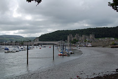 I did think about pottering around Conwy castle. After a brief circuit of the car park, an inspection of the entry fee, and my own darkening mood, I did a brief circuit of the town instead. It took several minutes to locate a way out, eventually finding a ludicrously steep descending lane that in turn fed me onto the coastal path. My mood brightened, I spun my way around the bay for half a mile or so and stopped to take some photographs. Out past the golf course and I was back in the countryside and as the motorists disappeared into the Penmaenbach Tunnels, I took on the infrastructure.
For the most part, it was very hard work. While motorists with unlimited horsepower glided past without a care in the world for gradient, and diesel trains rumbled along happily right by the sea wall, the cycle route lurched up and down, threaded its way through sheer cliffs and did right-angled turns past sharp-edged walls that caught my panniers more than once. To give Wales credit, there was barely any cycle route before, and they couldn't just magic a fantastical Dutch expressway out of thin air. "Shoehorned" might describe it. At Penmaenmawr the path opened out to a wide, paved promenade with a cafe and a playground and some shelters for weary travellers. It was a Saturday morning, and the place was almost deserted. The cafe and its occasional patron had a tired, motorway service station look, which is not that great loss considering the nondescript Edwardian promenade of much the same format that was swept away in the A55's construction. I sat out of the wind in one of the shelters and ate a banana and some flapjack. I looked up at the hillside and could make out a series of inclines and galleries and a few stone buildings. Quarries! Now I was getting somewhere, because quarries meant slate, probably, and slate meant I was on my way to Snowdon central.
The unlucky westbound cyclist from Penmaenmawr has to cope with an amazing construction. From sea level one is required to ride up an unsurfaced access road with a gradient of about 1 in 5. Add a camping load and it might as well be 1 in 1. Then, as the A55 hammers overhead on its massive columns, one navigates a series of hairpin bends bookmarking steeply graded ramps that would give a wheelchair user friction burns, all the while climbing madly to reach the top: the old road to Bangor, which here is of course Penmaenmawr high street. This convenient gash in the landscape so ably filled by enterprising civil engineers, clearly imagining all cyclists to possess thighs like Robert Förstemann, was in fact once the inclined tramway leading to (and from) the great Penmaen-mawr Quarries whose output once upon a time departed from the nearby jetty, now but a series of stumps. And in the process the top of Penmaenmawr mountain—literally "Head of the Great Stone"—was completely quarried away.
Having made it up onto the old road you can't stay on it, because it was subsumed by the dual carriageway. Instead, the cycle path diverts to sweep grandly over the road on a new bridge. One is afforded a splendid view of the Pen-y-clip Tunnel, and then the route cuts away and hides itself inland next to the eastbound carriageway. The land rises and falls again and, around the other side of the mountain, another new bridge takes you across the westbound lanes again. After so much buggering about, stop-start riding and winkling around corners, I arrived in Llanfairfechan. I'd been working on the bike hard enough that I'd quite forgotten about whether it was trying to rain or trying to be sunny and summery.
Sustrans gets a bad rap from a fair number of cyclists. Most of the complaints come from the highly experienced, or the fast and vehicular, or those riding trikes, towing trailers, or riding anything that isn't a cookie cutter "bicycle". Tandemistas, recumbent riders, and occasionally a lone velomobile pilot, know it all too well. I've strayed too close already to the epithet, "Sustrans barrier", but a greater percentage of the big S's route mileage is on good old blacktop, carefully surveyed, cycled, signposted and stickered. But after Llanfairfechan they really outdid themselves.
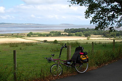 To be fair, there weren't many alternatives. I followed the old road to Abergwygregyn where at the big junction most people pointed their cars at one of the snaking little slip roads, to play with the other cars on the A55. My route turned south past a farm and immediately started climbing towards the trees. It was only the bitiest of country lanes, with tall hedgerows and overgrown gates to fields. I was concerned that a tractor, Chelsea or actual, might come thundering down the hill and not see until it was too late this laden cyclist winching along her lowest ratios. It was slow going and summer had arrived, so I crested a rise and parked under some trees and ate more flapjack. I could see the main road low down in the distance, on the flats before the sea.
After Crymlyn Farm the road started descending—at last—all the way to the next junction with the A55. It's a fine line between following a route that has been designed to accommodate the least experienced cyclist and being able to deviate from it in the name of efficiency. My maps were mostly buried in my pannier, and map reading involved stopping and faffing. So I mostly followed the blue signs and glanced at the cyan coloured line on my GPS. Had I known all of this I wouldn't have cycled three sides of a rectangle just to get to the next town! Come to think of it, I had the same issue in Ontario, following the cycle route through Oakville on the way to Burlington, on my way to Niagara-on-the-Lake.
On the main road into Tal-y-bont I caught up a group of mountain bikers. As the road descended in a great right-hand sweep to the bridge over Afon Ogwen I put the pedal to the metal and the thing to the floor, and overtook the lot of them. I impressed myself by managing to keep them out of sight as the road climbed out of the valley towards Llandygai. With a left and a right I took a country lane even smaller than the one before, with hedges even taller. I cycled over the route of the railway to Bangor—it's in a tunnel at this point but I wouldn't have known, unless I'd been on a ventilation shaft hunting expedition, which I wasn't—and came to a ford. Living in a city you tend not to encounter them. But there is one, is in the old village of Dean where the Water of Leith is about as accessible as it gets. At one time, and possibly not all that many years ago, there were great stone slabs, and you could drive your car down a precarious cobbled ramp, splosh your way through, and power up the cobbled road on the other side and hope your crossplies did their job. Now though the river is two or three feet deep and you have to use the pedestrian bridge. But here, perhaps half a mile from Bangor, the ford was flowing well and looked distinctly slidey. I decided that discretion was the better part of valour and took the footbrige.
Then Sustrans' planning really showed its worth. From the ford my lovely little country lane climbed upwards. I changed down the gears, and eventually reached '1'. The route ascended 75 metres, averaging 1 in 10-and-a-bit. That's quite steep and I've climbed worse in my velomobile. But the stinger was the section of 1 in 5 up to a junction, and with a full camping load I had to get off and push. Quite how a family would deal with a road like that is a good question. But I got to the very top at Minffordd eventually and plummeted down the other side to Glen-Adda on the southwestern side of Bangor.
I didn't know that Bangor was built in a valley, and promptly found myself another lung bursting and leg wrenchingly slow climb to the top of the ridge that runs southwest to northeast. My speed was little more than walking pace, about 4mph, I was sweating like a pig and I may have been gritting my teeth, but I wasn't going to get off and walk this time! Along the ridge I found a cheap little supermarket, staffed by a disinterested man who seemed to spend all his time talking with his regulars. Even when I was giving him money for Jelly Babies and crisps he barely managed a thank-you and a smile in my direction.
Shortly before yet another big junction with the A55, where it swings north to cross the Menai Straits, I turned north as well. Passing through the collection of houses of Ty'n-y-lôn my road reverted to country lane, which reverted to a roughly slabbed track as it plunged downhill. I wasn't looking forward to cycling back up, put it that way. And plunging downhill in these here parts meant only one thing. Above the trees strode the mighty Britannia Bridge. I passed underneath the southern end of the road deck, where the railway curves tightly to the right and hides underneath, and watched a train rumble its way towards Anglesey. A short way down the hill I found an access road. It seemed to be in the right sort of place, so I climbed up for a look.
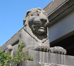 Silently and impassively keeping guard over the bridge, as it has done for 165 years, was my stone lion. Like his three brothers, he is simply magnificent. It's a tribute to an age when we built things and were so proud of them that we'd spend money on decorations to make them look even better. Looking all of their twelve feet tall, and sitting on their twelve feet tall plinths, the lions were in keeping with the hefty Egyptian themes of the bridge's masonry. They were carved by John Thomas, who produced many other splendid works, mostly of people, including statues for the then Euston Station. And while railway passengers were no doubt awed by the audacity of the Britannia Bridge, they had time to groan, too.
Pedwar llew tew
Heb ddim blew.
Dau 'ochr yma
A dau 'ochr drew.Four fat lions
Without any fur.
There's two over 'ere
And two over there.
John Evans no doubt thought himself a fine poet, but he was very much a contemporary of William McGonagall, who wrote so memorably about the Silv'ry Tay.
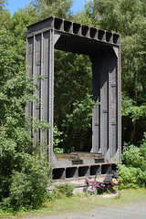 In the clearing further down the hill stands the other edifice that I'd wanted to see. In 1970 some teenagers were exploring one of the iron tubes of the bridge, their passage lit by a flaming torch. In the heat of the moment the torch was dropped. Imagine the debris left behind by a century of steam locomotives: ash, coal dust, lumps of coal, oil, oily rags. Imagine, also, the construction of the tube and its treatment: iron panels on all four sides, lined at the bottom with the railway's wooden sleepers, and at the top a wooden roof coated in tar. What could possibly go wrong? The burning torch caught the debris on the ground, and the flames seared up to the roof. Stephenson and company might have been brilliant engineers but firefighting and access/egress was possibly not high up their agenda. The teenagers might have survived—and are probably living lives of extraordinary shame—but the fire could not be put out. The flames and the heat travelled the whole length of the bridge and the great iron tubes were ruined: still in place but distorted and brittle, with rivet heads popped out of place and panelling buckled and stressed.
It's perhaps just as well that a new road bridge to Anglesey was needed at the same time, because British Rail was in a frenzy of closures, and would doubtless have been happy to close the railway entirely and demolish the bridge. Happily, perhaps, the bridge was saved by rebuilding it with two main steel arches supporting a new railbed, and the huge stone pillars were cut through to build the road deck above. Although the majority of the iron was now scrap, one section was preserved, in the clearing where I was now standing. I thought it was rather an ignominious end. Of course it should be displayed next to its home, and of course the monument should have its own bronze plaque, but it's practically forgotten in the middle of nowhere with no tourist signs to guide the visitor.
As I walked my bike back up the steep bank of Afon Menai, I did wonder whether the lack of signs was for the best. It would be a terrible thing for a new generation of teenagers, bored with their electronic toys, to discover the lions. But already the sheltered area under the road deck is the site of bonfires and drinking, and palisade fencing is only so good. In Stephenson's day they'd be given the cane for such insolence.
The sun was out in force, and I was surprisingly tired and close to the dreaded bonk, as in, 'I think I need to sit down right now, please.' I cycled back to the main road, found a bench, and ate the entire bag of crisps, half a banana and drank great quantities of chocolate milk. While I gathered my strength I chatted with a man who was mowing his lawn nearby.
'That's a comfortable looking bike! You look like you're going a long way. Where you off to?'
'I'm on my way to Llanberis. Not too far to go I think!'
'Which way are you going to go?'
'I was planning to cut across in that direction,' I said, pointing south, 'about 12 miles or so.'
'There's a bloody big hill that way you know, and the drivers are crazy these days. You can go around; go down the hill and take the old railway line to Caernarfon and then come in on the main road. It's more level.'
I had no idea what he was talking about. 'I don't mind hills too much. I've had quite a lot of experience.'
'Have you got a map?'
'Aye, I've got my OS map and my GPS. Is it much further going that way?'
'Few miles more I'd say.'
'Ok, I'll check it out. Thanks!'
Frankly I wanted to get to Llanberis as quickly as I could, and I had no intention of trying to navigate off-route. I headed west out of town on the A487 which didn't seem too crazy to me, and then took the B4547. Quieter and quite enjoyable. The road turned left and started climbing, into the trees and into the shade. This was becoming a recurring theme, I noticed. Before long I was rounding a long curve in almost bottom gear while trying to take the lane. The drivers were in fact crazy, I decided, as time and again they sped past as close as possible to me, as though the white line was covered in spikes. Once it levelled out I accelerated and shot across a roundabout, held my speed for a while but then road started to climb again. The A4244 might be a wide S2 type road but the drivers were completely insane. I may have turned the air very blue on more than one occasion. It was a long hill and the traffic was spurring me to ride faster than I needed. What difference to them, hurtling up the hill at 60mph or more, would it have made were I riding at 4mph or 8mph? Or 15mph? I should have saved my energy. After what felt like about an hour's worth of climbing, but amazingly was only ten minutes, I reached a petrol station. I was nearly dying. I sat on some big boulders, tore open a bright yellow plastic bag and chomped as fast as I could on several Jelly Babies. The other half of my banana disappeared even quicker.
I ought to have stayed longer but impatience got the better of me. I relaxed as I dropped quickly down the far slopes of Moel Rhiwen. Terminal velocity seemed to be about 35mph, and that was fast enough for me in those conditions. Once into the valley floor by the Afon Rhythallt which empties itself at Caernarfon, I was riding upstream so I was climbing again. Fortunately the worst of it, and the road was pretty narrow at the best of times anyway, is where they've built a reasonably wide footway that is also the cycle path. I was glad to take it, and as soon as I left the tarmac I also stopped rushing, and settled into a friendly stress-free rhythm. Lake Padarn to my left stretched out into the mist. Mist? Yes, it was actually attempting to rain by this point. I think the actual word is "mizzle". The lake was my friend all the way to Llanberis. I waved to a couple riding equally heavily loaded touring bikes, all bright red Ortliebs and stout tyres.
Llanberis looked like your typical one-road village. It reminded me of South Queensferry; there were strings of shops selling everything from antiques and buckets and spades to paninis and waterproofs; cosy B&Bs with flowerboxes in the garden competed with converted grand houses with cars in the garden; the derelict petrol station was thrown in for contrast, I assumed. I found the road to my campsite—Llwyn Celyn Bach—and started up the hill. It seemed fairly steep but nothing I hadn't encountered already today. Then it got steeper. A turn here, a turn there, and it got even steeper again. By the time I was almost out of the trees my heart had nearly burst through my chest and my legs were more lactic acid than muscle. It was all I could do to push my bike to the top. After all that effort I surveyed my surroundings.
"I seem to have found the world's slopiest campsite at the top of the world's steepest hill."
I quickly realised there wasn't a level bit of ground anywhere. How the hell was I going to manage to sleep here? I was so utterly worn out after 35 miles that I couldn't face climbing that road again. I phoned various establishments and only one had a vacancy. I decided it was worth trying, and after much thinking I took off back down the hill, my brakes grinding themselves into oblivion. I soon discovered why the hotel had a vacancy. With its brown reception desk, pictures all faded to buggery, a hall with brown and red threadbare carpeting, and a "Break Glass" fire alarm all taped over, the hotel probably had lots of vacancies. I went with my gut feeling and I shot out of the place before anyone tried to help me.
'Bollocks!' I think I said.
Since I was at ground level I cycled all the way to the other end of the village to have a look at the Snowdon Mountain Railway station, and to scope out the area for bike parking. Research purposes, you see. There wasn't any bike parking. I'd heard rumours that the weather for the next day wasn't meant to be very good, and I asked at the station ticket office. A lady who'd found herself with a spare ticket for the railway asked me if I wanted to buy it and enjoy the views while the sun was out. It was only mid-afternoon. I thanked her and carried on with my day, deciding that getting my tent up was more important. There was a hullabaloo in the park opposite the station with catering tents and gazebos going up. Some sort of charity event I thought, maybe a mountain bike race. I needed some food for dinner anyway, so I popped into the supermarket. After a bit more aimless riding up and down there was nothing for it but to go back to the campsite, and I wasn't feeling any stronger.
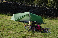
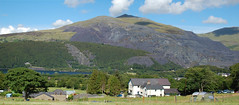 Back at the top I picked what looked like the least sloping bit of ground that was left, next to a wall, and set to work in the sunshine. From the campsite you can look right across to Dinorwic Quarry. It is absolutely enormous. Inclines, huge layers of grey spoil, more inclines, a few scattered buildings high up… In another direction you can just see the mountain railway. I could actually hear the little engine as it chuffed its way up towards the summit, and I wondered whether I should have taken up that offer.
A motorbiker arrived while I was making my dinner. Big old Yamaha FJ with Krauser boxes. He poked around for a few minutes, puttered off up the hill, and then came back down and disappeared into town. Llanberis was defintely bike-with-an-engine sort of terrain, but I decided that the ground of the campsite was just too steep for parking a motorbike safely. In one direction your bike wouldn't lean over far enough to sit on its propstand, and in the other direction it would lean so far it would fall over immediately and be impossible to lift. I was coming back from washing up when the motorbiker returned. Obviously he'd not found any vacancies either. He was investigating the least sloping bit of ground after mine, and I realised the rocky bit next to the gate might actually do, so I pointed. He nodded and came over, and I helped him find a better option to keep his bike upright. As he threw up his tent and fiddled with a can of lube we got chatting. Whereabouts have you come from? Have you done much touring? Of all the people to meet in this particular campsite on this particular day it turned out that, back home, he rode an Africa Twin. Well! Instant friendship. Tall, long hair, muscular, adventurous…damn.
Neither of us had anyone else to talk to, so we wandered down the hill and found a bar that was doing evening food. I'd already eaten dinner, of course, but I did find room for mushroom soup and a drink. It was refreshing to have some conversation, and it was dark when we walked back up to the campsite.
And like two passing ships, I returned to my tent, quite the warmest place to be by this point, snuggled into my sleeping bag and read about midwifery.

3 comments:
One of the most British travelogues I have ever read.
I'm a bit surprised by your last sentence. I didn't know they allowed blind people to have motorcycle licenses in the U.K.
That was fun although your GPS should have insisted on a breather at Llanfairfechan seafront with an ice cream just because! Am also aware of that Ford after deciding to mix things up on a 4 wheeled trip to Bangor last year...was the railway you referred to their the rail-trail that runs from Bethesda to Bangor?
Post a Comment