October 19, 2015

The road leads cursed and charmed

The A55 from Chester to Bangor is a lovely road, a great big smooth dual carriageway. It flows through green countryside following the contours and skirts the flatlands by the coast. It plays catch with the railway that threads its own way along the coast and past cliff faces. After Conwy it takes on an alpine air as it hugs the hills, twists and turns on enormous elevated concrete viaducts, and plunges gleefully into excitingly dark tunnels guarded by big signs with red and green lights.

If you're a cyclist, the A55 is a total pain in the arse.

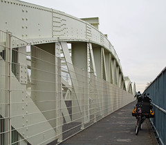
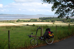
It used to be worse. At one time, and not so very long ago, it was practically impossible to cycle west out of Conwy and stay within sight of the coast. You could do it, but it involved a narrow footway right next to traffic coming towards you at 60mph. Then someone had a huge injection of cash, and infrastructure was built. Great steel bridges were erected. Cliff faces were tamed with Gabion baskets and dovetailed concrete slabs and huge bolts. Parapet walls were rebuilt, footways were resurfaced and widened. It was this newfangled cycling facility that lured me—dared me—to Wales to try it out. Mainly for research purposes, you understand, and partly out of bloodymindedness. My itinerary for the day was fewer miles than Chester to Rhôs on Sea, but more industrial. And not just in the sights.

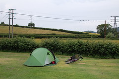
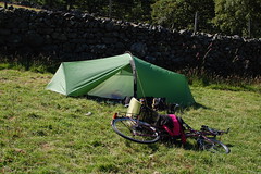
I always have a bit of a blind spot taking down my tent: I stand and stare at it, hands on hips, trying to work out whether to unpeg it first and then pull the poles out, or the other way around, or a bit of both. Do I fold it neatly, or stuff it? As it was, I was ready to leave Dinarth Hall before ten o'clock. I fared better than some others on the campsite, though. Several people had left their four-poster gazebos standing when they went to bed, and the wind overnight took down every one of them. But while they luxuriated in their duvets under rigid fibreglass, and I in my cosy little down bag, I had a pretty poor night as my tent's fly flapped this way and that. Broken sleep does strange things to you.

"Dreamed that I watched a Deltic rounding a tight left-hand turn at Prestonpans (!) and it overturned almost where I was standing watching! Class 91s in Electra livery came to the rescue.

I looked at the sky and it was overcast. The wind was still up, too, but at least the air pressure had crept up a fraction to 1013mb. But it's only weather, and I had a waterproof with me just in case. The campsite had a back lane with a gate at the end. I'd seen it when I arrived and was choosing my pitch, but I'd presumed that it would be locked. After all, you can't have every Tom, Dick and Harry rocking up with their seventeen-person canvas headquarters and flushing your toilets like they own the place. I therefore had to go right the way around the farm, past my supermarket and along and down, saying hello to the back gate on my way. As I made my merry way through the country lanes I realised that I hadn't refilled my water bottles again. I remembered the cold water tap and decided I'd stop by. Well if the back gate wasn't only bloody well wide open! I rode past my former tent pitch, filled up, and hauled my heavy bike back on the way to tubular bridge country. At least it was a pleasant two-mile warm up.

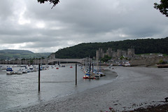
Getting to Conwy was surprisingly difficult. I wafted around the edge of Llandudno Junction and saw the bridges over the river, first Stephenson's baby tubular railway bridge, behind it Telford's chain suspension road bridge, and behind that the modern concrete arch road bridge that carries the traffic nowadays. I would have happily followed the signs and stayed on the A547 but the Sustrans route took me on a wild goose chase away from the roundabout I was nearly at, under the big scary road, through an industrial estate and dumped me on the road north heading towards Platt and Conwy Bay. This wasn't where was I meant to be going.

'For crying out loud!' I shouted, stabbing the zoom buttons on my GPS, turning right and putting back on my Experienced Cyclist hat. I powered up to the roundabout, hauled my bike hard right and headed down the promontory. I jinked left at the last minute to take the Telford bridge over the river and hit the brakes. 'What? A Pound?' I exclaimed as I saw that the bridge was gated and a fare was chargeable. It might be a National Trust site and quite rightly, but it was ridiculous. I'd walked the bridge before, from the castle side with a friend, and I've no idea if we were supposed to have paid or not for the privilege. Where on earth was the cycle route?

'Oh for heaven's sake!' I shouted, and I launched myself into the mêlée of cars being driven ten to the dozen into the historic town.

It should be noted that the cycle route does in fact exist. Just after going under Big Scary Road you turn right and go up a ramp with a hairpin corner halfway up, and it brings you out onto the footway on the north side of the road. Simple. Of course this means you're still on the wrong side of the road when you get to the other end.

The way out of Conwy I did think about pottering around Conwy castle. After a brief circuit of the car park, an inspection of the entry fee, and my own darkening mood, I did a brief circuit of the town instead. It took several minutes to locate a way out, eventually finding a ludicrously steep descending lane that in turn fed me onto the coastal path. My mood brightened, I spun my way around the bay for half a mile or so and stopped to take some photographs. Out past the golf course and I was back in the countryside and as the motorists disappeared into the Penmaenbach Tunnels, I took on the infrastructure.

For the most part, it was very hard work. While motorists with unlimited horsepower glided past without a care in the world for gradient, and diesel trains rumbled along happily right by the sea wall, the cycle route lurched up and down, threaded its way through sheer cliffs and did right-angled turns past sharp-edged walls that caught my panniers more than once. To give Wales credit, there was barely any cycle route before, and they couldn't just magic a fantastical Dutch expressway out of thin air. "Shoehorned" might describe it. At Penmaenmawr the path opened out to a wide, paved promenade with a cafe and a playground and some shelters for weary travellers. It was a Saturday morning, and the place was almost deserted. The cafe and its occasional patron had a tired, motorway service station look, which is not that great loss considering the nondescript Edwardian promenade of much the same format that was swept away in the A55's construction. I sat out of the wind in one of the shelters and ate a banana and some flapjack. I looked up at the hillside and could make out a series of inclines and galleries and a few stone buildings. Quarries! Now I was getting somewhere, because quarries meant slate, probably, and slate meant I was on my way to Snowdon central.

The unlucky westbound cyclist from Penmaenmawr has to cope with an amazing construction. From sea level one is required to ride up an unsurfaced access road with a gradient of about 1 in 5. Add a camping load and it might as well be 1 in 1. Then, as the A55 hammers overhead on its massive columns, one navigates a series of hairpin bends bookmarking steeply graded ramps that would give a wheelchair user friction burns, all the while climbing madly to reach the top: the old road to Bangor, which here is of course Penmaenmawr high street. This convenient gash in the landscape so ably filled by enterprising civil engineers, clearly imagining all cyclists to possess thighs like Robert Förstemann, was in fact once the inclined tramway leading to (and from) the great Penmaen-mawr Quarries whose output once upon a time departed from the nearby jetty, now but a series of stumps. And in the process the top of Penmaenmawr mountain—literally "Head of the Great Stone"—was completely quarried away.

Having made it up onto the old road you can't stay on it, because it was subsumed by the dual carriageway. Instead, the cycle path diverts to sweep grandly over the road on a new bridge. One is afforded a splendid view of the Pen-y-clip Tunnel, and then the route cuts away and hides itself inland next to the eastbound carriageway. The land rises and falls again and, around the other side of the mountain, another new bridge takes you across the westbound lanes again. After so much buggering about, stop-start riding and winkling around corners, I arrived in Llanfairfechan. I'd been working on the bike hard enough that I'd quite forgotten about whether it was trying to rain or trying to be sunny and summery.

Sustrans gets a bad rap from a fair number of cyclists. Most of the complaints come from the highly experienced, or the fast and vehicular, or those riding trikes, towing trailers, or riding anything that isn't a cookie cutter "bicycle". Tandemistas, recumbent riders, and occasionally a lone velomobile pilot, know it all too well. I've strayed too close already to the epithet, "Sustrans barrier", but a greater percentage of the big S's route mileage is on good old blacktop, carefully surveyed, cycled, signposted and stickered. But after Llanfairfechan they really outdid themselves.

Sustrans' best To be fair, there weren't many alternatives. I followed the old road to Abergwygregyn where at the big junction most people pointed their cars at one of the snaking little slip roads, to play with the other cars on the A55. My route turned south past a farm and immediately started climbing towards the trees. It was only the bitiest of country lanes, with tall hedgerows and overgrown gates to fields. I was concerned that a tractor, Chelsea or actual, might come thundering down the hill and not see until it was too late this laden cyclist winching along her lowest ratios. It was slow going and summer had arrived, so I crested a rise and parked under some trees and ate more flapjack. I could see the main road low down in the distance, on the flats before the sea.

After Crymlyn Farm the road started descending—at last—all the way to the next junction with the A55. It's a fine line between following a route that has been designed to accommodate the least experienced cyclist and being able to deviate from it in the name of efficiency. My maps were mostly buried in my pannier, and map reading involved stopping and faffing. So I mostly followed the blue signs and glanced at the cyan coloured line on my GPS. Had I known all of this I wouldn't have cycled three sides of a rectangle just to get to the next town! Come to think of it, I had the same issue in Ontario, following the cycle route through Oakville on the way to Burlington, on my way to Niagara-on-the-Lake.

On the main road into Tal-y-bont I caught up a group of mountain bikers. As the road descended in a great right-hand sweep to the bridge over Afon Ogwen I put the pedal to the metal and the thing to the floor, and overtook the lot of them. I impressed myself by managing to keep them out of sight as the road climbed out of the valley towards Llandygai. With a left and a right I took a country lane even smaller than the one before, with hedges even taller. I cycled over the route of the railway to Bangor—it's in a tunnel at this point but I wouldn't have known, unless I'd been on a ventilation shaft hunting expedition, which I wasn't—and came to a ford. Living in a city you tend not to encounter them. But there is one, is in the old village of Dean where the Water of Leith is about as accessible as it gets. At one time, and possibly not all that many years ago, there were great stone slabs, and you could drive your car down a precarious cobbled ramp, splosh your way through, and power up the cobbled road on the other side and hope your crossplies did their job. Now though the river is two or three feet deep and you have to use the pedestrian bridge. But here, perhaps half a mile from Bangor, the ford was flowing well and looked distinctly slidey. I decided that discretion was the better part of valour and took the footbrige.

Then Sustrans' planning really showed its worth. From the ford my lovely little country lane climbed upwards. I changed down the gears, and eventually reached '1'. The route ascended 75 metres, averaging 1 in 10-and-a-bit. That's quite steep and I've climbed worse in my velomobile. But the stinger was the section of 1 in 5 up to a junction, and with a full camping load I had to get off and push. Quite how a family would deal with a road like that is a good question. But I got to the very top at Minffordd eventually and plummeted down the other side to Glen-Adda on the southwestern side of Bangor.

I didn't know that Bangor was built in a valley, and promptly found myself another lung bursting and leg wrenchingly slow climb to the top of the ridge that runs southwest to northeast. My speed was little more than walking pace, about 4mph, I was sweating like a pig and I may have been gritting my teeth, but I wasn't going to get off and walk this time! Along the ridge I found a cheap little supermarket, staffed by a disinterested man who seemed to spend all his time talking with his regulars. Even when I was giving him money for Jelly Babies and crisps he barely managed a thank-you and a smile in my direction.

Shortly before yet another big junction with the A55, where it swings north to cross the Menai Straits, I turned north as well. Passing through the collection of houses of Ty'n-y-lôn my road reverted to country lane, which reverted to a roughly slabbed track as it plunged downhill. I wasn't looking forward to cycling back up, put it that way. And plunging downhill in these here parts meant only one thing. Above the trees strode the mighty Britannia Bridge. I passed underneath the southern end of the road deck, where the railway curves tightly to the right and hides underneath, and watched a train rumble its way towards Anglesey. A short way down the hill I found an access road. It seemed to be in the right sort of place, so I climbed up for a look.

Stephenson's lions 
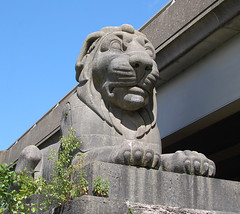
Silently and impassively keeping guard over the bridge, as it has done for 165 years, was my stone lion. Like his three brothers, he is simply magnificent. It's a tribute to an age when we built things and were so proud of them that we'd spend money on decorations to make them look even better. Looking all of their twelve feet tall, and sitting on their twelve feet tall plinths, the lions were in keeping with the hefty Egyptian themes of the bridge's masonry. They were carved by John Thomas, who produced many other splendid works, mostly of people, including statues for the then Euston Station. And while railway passengers were no doubt awed by the audacity of the Britannia Bridge, they had time to groan, too.

Pedwar llew tew

Heb ddim blew.

Dau 'ochr yma

A dau 'ochr drew.

Four fat lions

Without any fur.

There's two over 'ere

And two over there.

John Evans no doubt thought himself a fine poet, but he was very much a contemporary of William McGonagall, who wrote so memorably about the Silv'ry Tay.

Bent box 
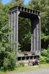
In the clearing further down the hill stands the other edifice that I'd wanted to see. In 1970 some teenagers were exploring one of the iron tubes of the bridge, their passage lit by a flaming torch. In the heat of the moment the torch was dropped. Imagine the debris left behind by a century of steam locomotives: ash, coal dust, lumps of coal, oil, oily rags. Imagine, also, the construction of the tube and its treatment: iron panels on all four sides, lined at the bottom with the railway's wooden sleepers, and at the top a wooden roof coated in tar. What could possibly go wrong? The burning torch caught the debris on the ground, and the flames seared up to the roof. Stephenson and company might have been brilliant engineers but firefighting and access/egress was possibly not high up their agenda. The teenagers might have survived—and are probably living lives of extraordinary shame—but the fire could not be put out. The flames and the heat travelled the whole length of the bridge and the great iron tubes were ruined: still in place but distorted and brittle, with rivet heads popped out of place and panelling buckled and stressed.

It's perhaps just as well that a new road bridge to Anglesey was needed at the same time, because British Rail was in a frenzy of closures, and would doubtless have been happy to close the railway entirely and demolish the bridge. Happily, perhaps, the bridge was saved by rebuilding it with two main steel arches supporting a new railbed, and the huge stone pillars were cut through to build the road deck above. Although the majority of the iron was now scrap, one section was preserved, in the clearing where I was now standing. I thought it was rather an ignominious end. Of course it should be displayed next to its home, and of course the monument should have its own bronze plaque, but it's practically forgotten in the middle of nowhere with no tourist signs to guide the visitor.

As I walked my bike back up the steep bank of Afon Menai, I did wonder whether the lack of signs was for the best. It would be a terrible thing for a new generation of teenagers, bored with their electronic toys, to discover the lions. But already the sheltered area under the road deck is the site of bonfires and drinking, and palisade fencing is only so good. In Stephenson's day they'd be given the cane for such insolence.

The sun was out in force, and I was surprisingly tired and close to the dreaded bonk, as in, 'I think I need to sit down right now, please.' I cycled back to the main road, found a bench, and ate the entire bag of crisps, half a banana and drank great quantities of chocolate milk. While I gathered my strength I chatted with a man who was mowing his lawn nearby.
'That's a comfortable looking bike! You look like you're going a long way. Where you off to?'
'I'm on my way to Llanberis. Not too far to go I think!'
'Which way are you going to go?'
'I was planning to cut across in that direction,' I said, pointing south, 'about 12 miles or so.'
'There's a bloody big hill that way you know, and the drivers are crazy these days. You can go around; go down the hill and take the old railway line to Caernarfon and then come in on the main road. It's more level.'
I had no idea what he was talking about. 'I don't mind hills too much. I've had quite a lot of experience.'
'Have you got a map?'
'Aye, I've got my OS map and my GPS. Is it much further going that way?'
'Few miles more I'd say.'
'Ok, I'll check it out. Thanks!'

Frankly I wanted to get to Llanberis as quickly as I could, and I had no intention of trying to navigate off-route. I headed west out of town on the A487 which didn't seem too crazy to me, and then took the B4547. Quieter and quite enjoyable. The road turned left and started climbing, into the trees and into the shade. This was becoming a recurring theme, I noticed. Before long I was rounding a long curve in almost bottom gear while trying to take the lane. The drivers were in fact crazy, I decided, as time and again they sped past as close as possible to me, as though the white line was covered in spikes. Once it levelled out I accelerated and shot across a roundabout, held my speed for a while but then road started to climb again. The A4244 might be a wide S2 type road but the drivers were completely insane. I may have turned the air very blue on more than one occasion. It was a long hill and the traffic was spurring me to ride faster than I needed. What difference to them, hurtling up the hill at 60mph or more, would it have made were I riding at 4mph or 8mph? Or 15mph? I should have saved my energy. After what felt like about an hour's worth of climbing, but amazingly was only ten minutes, I reached a petrol station. I was nearly dying. I sat on some big boulders, tore open a bright yellow plastic bag and chomped as fast as I could on several Jelly Babies. The other half of my banana disappeared even quicker.

I ought to have stayed longer but impatience got the better of me. I relaxed as I dropped quickly down the far slopes of Moel Rhiwen. Terminal velocity seemed to be about 35mph, and that was fast enough for me in those conditions. Once into the valley floor by the Afon Rhythallt which empties itself at Caernarfon, I was riding upstream so I was climbing again. Fortunately the worst of it, and the road was pretty narrow at the best of times anyway, is where they've built a reasonably wide footway that is also the cycle path. I was glad to take it, and as soon as I left the tarmac I also stopped rushing, and settled into a friendly stress-free rhythm. Lake Padarn to my left stretched out into the mist. Mist? Yes, it was actually attempting to rain by this point. I think the actual word is "mizzle". The lake was my friend all the way to Llanberis. I waved to a couple riding equally heavily loaded touring bikes, all bright red Ortliebs and stout tyres.

Llanberis looked like your typical one-road village. It reminded me of South Queensferry; there were strings of shops selling everything from antiques and buckets and spades to paninis and waterproofs; cosy B&Bs with flowerboxes in the garden competed with converted grand houses with cars in the garden; the derelict petrol station was thrown in for contrast, I assumed. I found the road to my campsite—Llwyn Celyn Bach—and started up the hill. It seemed fairly steep but nothing I hadn't encountered already today. Then it got steeper. A turn here, a turn there, and it got even steeper again. By the time I was almost out of the trees my heart had nearly burst through my chest and my legs were more lactic acid than muscle. It was all I could do to push my bike to the top. After all that effort I surveyed my surroundings.

"I seem to have found the world's slopiest campsite at the top of the world's steepest hill."

I quickly realised there wasn't a level bit of ground anywhere. How the hell was I going to manage to sleep here? I was so utterly worn out after 35 miles that I couldn't face climbing that road again. I phoned various establishments and only one had a vacancy. I decided it was worth trying, and after much thinking I took off back down the hill, my brakes grinding themselves into oblivion. I soon discovered why the hotel had a vacancy. With its brown reception desk, pictures all faded to buggery, a hall with brown and red threadbare carpeting, and a "Break Glass" fire alarm all taped over, the hotel probably had lots of vacancies. I went with my gut feeling and I shot out of the place before anyone tried to help me.

'Bollocks!' I think I said.

Since I was at ground level I cycled all the way to the other end of the village to have a look at the Snowdon Mountain Railway station, and to scope out the area for bike parking. Research purposes, you see. There wasn't any bike parking. I'd heard rumours that the weather for the next day wasn't meant to be very good, and I asked at the station ticket office. A lady who'd found herself with a spare ticket for the railway asked me if I wanted to buy it and enjoy the views while the sun was out. It was only mid-afternoon. I thanked her and carried on with my day, deciding that getting my tent up was more important. There was a hullabaloo in the park opposite the station with catering tents and gazebos going up. Some sort of charity event I thought, maybe a mountain bike race. I needed some food for dinner anyway, so I popped into the supermarket. After a bit more aimless riding up and down there was nothing for it but to go back to the campsite, and I wasn't feeling any stronger.

It's a slippery slope, this camping thing How to steal a mountain 
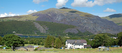
Back at the top I picked what looked like the least sloping bit of ground that was left, next to a wall, and set to work in the sunshine. From the campsite you can look right across to Dinorwic Quarry. It is absolutely enormous. Inclines, huge layers of grey spoil, more inclines, a few scattered buildings high up… In another direction you can just see the mountain railway. I could actually hear the little engine as it chuffed its way up towards the summit, and I wondered whether I should have taken up that offer.

A motorbiker arrived while I was making my dinner. Big old Yamaha FJ with Krauser boxes. He poked around for a few minutes, puttered off up the hill, and then came back down and disappeared into town. Llanberis was defintely bike-with-an-engine sort of terrain, but I decided that the ground of the campsite was just too steep for parking a motorbike safely. In one direction your bike wouldn't lean over far enough to sit on its propstand, and in the other direction it would lean so far it would fall over immediately and be impossible to lift. I was coming back from washing up when the motorbiker returned. Obviously he'd not found any vacancies either. He was investigating the least sloping bit of ground after mine, and I realised the rocky bit next to the gate might actually do, so I pointed. He nodded and came over, and I helped him find a better option to keep his bike upright. As he threw up his tent and fiddled with a can of lube we got chatting. Whereabouts have you come from? Have you done much touring? Of all the people to meet in this particular campsite on this particular day it turned out that, back home, he rode an Africa Twin. Well! Instant friendship. Tall, long hair, muscular, adventurous…damn.

Neither of us had anyone else to talk to, so we wandered down the hill and found a bar that was doing evening food. I'd already eaten dinner, of course, but I did find room for mushroom soup and a drink. It was refreshing to have some conversation, and it was dark when we walked back up to the campsite.

And like two passing ships, I returned to my tent, quite the warmest place to be by this point, snuggled into my sleeping bag and read about midwifery.

October 14, 2015

Travel we say, wander we choose

'It'll be alright once I'm on the move,' I told myself over bran flakes at breakfast time. A mile down the road I realised I hadn't filled my water bottles. Having already checked out of the hostel I snuck back in, using the door code I'd handily photographed earlier, and sped through to the kitchen and back out again. The guy at the desk wasn't even there.

Being a battle-hardened outdoorsy sort of gal, I was wearing my weather station watch that does all sorts of scientific, weathery things, it bleeps in seven different ways and tells you the time in Caracas. Just because I could, I pressed the middle button and it said 24.4ºC. It certainly wasn't 24.4ºC in the air rushing past my face as I tried and failed to ride out of town at a relaxed touring sort of pace.

During my evening of GPS programming I'd decided that for much of the route I could follow my nose, and follow the Sustrans National Cycle Network signs the rest of the time, so I approximated great swathes of here-to-there. The fiddly bits, like the road junctions in Conwy and the road out of Porthmadog, needed tighter planning with more data points. 'How hard can it be?' I thought as I was reaching the access point onto the old railway line. 'I just have to turn left…here, and, oh, no that's wrong. Bugger it, I'm way past the turn off.' I turned around. I could see the old railway, because it was 20 feet above me on a bridge. A GPS with a five-year old street map does tend to get caught out from time to time. I retraced my route, rode too far, doubled back again and as an experiment took a trip into a quiet-looking cul-de-sac with posh new houses that probably cost half a million each. I discovered a gap in the wooden fence, and next to it a shiny blue sign with a bicycle symbol. See, stuff has a habit of working out like that.

Temporarily disorientated I studied the nearby signpost for clues. A minute or two later a man riding a Moulton AM arrived. 'Nice bike!' I said approvingly.
'I used to have a recumbent, you know, made by Trek. But I couldn't really get the hang of it.'
'I remember that one, the R200 with the red frame shaped like a stick?'
'Aye that's it. Is that one comfortable? Have you come far?'
'It's lovely,' I said, 'it's like an armchair.' I bounced up and down on the seat to prove it. 'And no, just from town today.'
'Are you lost? Do you need any directions?'
I laughed. 'Actually I know exactly where I am. I'm just wondering which way to go. Is Hawarden Bridge that way?' I said, pointing in the direction of Hawarden Bridge.

The big swing bridge After a few minutes I managed to escape and powered along the disused railway. It was once part of the Great Central Railway route joining the North Wales and Liverpool Railway and the Wrexham, Mold and Connah's Quay Railway. After Nationalisation it was all controlled by the LNER. Now it was NCN Route 5 and belonged to dog walkers and cyclists. In the other direction it was once the Cheshire Lines Railway to Northwich, and part of it too is now Route 5. You can only follow it as far as Mickle Trafford because they're still using the rest of the railway line. You can deal with the roads after that. I took some photographs of the great swing bridge at Hawarden, its asymmetric 'hogback' main truss and second and third trusses all in a rather pleasing cream colour. Then it tried to rain.

I'd already cycled further out of Chester than I'd been before. The last time, which was nine years earlier, a friend and I had followed the path on the north side of the River Dee, as far as Queensferry. We must've gone out late because it was summer and it got dark as we turned back. My friend switched on the lights on her bike. I say 'lights' but they were the feeblest things I'd ever seen. She would've been better holding a glow worm. She might've been riding a bike, but she wasn't a cyclist as such; she didn't arrange her life around using her bike in the way that I did. I pressed a rubbery blue switch on my handlebars and blazed out fifteen Watts of pure halogen power. LEDs weren't up to much back then, and we were all riding around with honking great battery packs that could quite easily double as blunt weapons. Vistalite actually called them their 'Nightstick' series. Now of course you can buy a powerful bike light that's so small it could fit into the useless little side pocket they keep sewing into jeans.

It wasn't long before I left the cosy cycle path and rejoined the roads. The A548 was mostly easy riding with occasional dashes of well graded dual carriageway. In a town somewhere along the way I stopped at a petrol station to buy a couple of bananas. I find riding with a group quite difficult because my eating routine gets sidelined in the name of progress. When they want to stop, I'm just getting on top of my digestion. On my own, I had the perfect opportunity to eat what I damn well liked and when I liked. I learned from riding the Erie Canal that I seemed to work best on bananas, crisps, chocolate milk and water. I learned from friends that jelly babies make quite a good energy gel substitute, and are certainly more palatable. I understand. I've never eaten an energy gel, but I've heard they're like eating bogies. The petrol station could only sell me an entire bunch of bananas, which was a problem because I had little enough spare space already. I did the sensible thing, then, and bought a huge bag of cheesy crisps as well.

On the way to Rhyl were a couple of outbreaks of Art Deco in neat orange brick rather than pastel plasterwork, and then a huge rusting ship sitting beyond a ramshackle open air market. I harboured thoughts of deviating for a wee explore, but I was in a hurry and didn't really fancy taking my chances. The market looked like it might be guarded by dogs and men with salivating chops. What on earth was a ship doing here? Originally it was the TSS Duke of Lancaster, a passenger-only steam ferry built for British Railways in the 1950s. It plied the Scottish islands and, as a cruise ship, travelled all over Europe. Later it was converted to carry cars as well as people, but in 1978 it all ended and the Lancaster was laid up in Cumbria. Then in 1979 it was brought to the north Wales coast as "the Fun Ship", a sort of arcade gaming and bars and entertainment venue. It closed in 2004 and has sat rusting ever since.

I was making good speed along the roads and the drivers were mostly behaving themselves, but I was quite happy to get back onto the cycle path. I turned off at Talacre and rode along a path that felt like it was made of railway ballast. After shoehorning my bike—CAUTION: WIDE LOAD—through yet another Sustrans barrier, the kind that tapers towards the top so that it jams your panniers, your handlebars and your shoulders, I emerged next to the mudflats of the Point of Ayr. The path surface improved and I sped up nicely, heeling into fast turns as the tarmac wandered around vaguely. The landscape was part nature reserve and part post-industrial, concrete paved wasteland, with complicated looking gas pipelines in the background. Until the mid-1990s it was the Point of Ayr Colliery, but now its edges are gradually being reclaimed by nature.

Then I got lost. The path had gone along the embankment, across a car park, along a nice little boardwalk with butterflies and flowers, and fed me into the dunes. On foot or perhaps on a mountain bike it would be a lovely excursion; on a touring bike almost too heavy to lift it was ridiculous. I turned back to the embankment and thought about riding on the beach. The tide was out, after all, and there were cars parked out there. The big coloured map on a signpost was no help whatsoever. It didn't even have north pointing up the way.

'But the GPS said it was this way!' I muttered to anyone who might've been listening. Clearly the GPS was programmed by an idiot. I finally spotted the tiny little blue arrow sign, stuck to one of those tapered barriers that jams your handlebars. It was so obvious, while hiding itself quietly in some bramble bushes. And we were on the move again, and heading west. Presthaven holiday park was an endless series of static caravans, some not even with wheels anymore, others with white picket fences. For some reason I was fascinated by the waste pipes hanging down underneath them all. Children with bicycles padded around in bare feet, and their parents wandered around walking their dogs or chatted to each other with their arms folded. I found my way out of the park and missed the turning for the path through the golf course because the road into the park was full of queueing cars. The seafront promenade that stretches for a mile or more was smooth jointed concrete and no jagged bits of seashells. It was very quiet.

Pausing in Prestatyn I stopped to eat a banana and watched the offshore wind farm. It was lunchtime but I didn't have lunch with me, only millions of snacks. When I did a loop through the Moorfoots to Innerleithen and Peebles, at lunchtime I attempted to eat an entire baked potato full of Coronation Chicken. I brought a third of it home again in clingfilm, while the other two-thirds took the rest of the day to digest, instead of giving me energy for the homeward bash. This time I was thinking simplicity. I set off again, and straight into enormous quantities of flies. They were everywhere, going up the arms of my t-shirt, under my cap, behind my glasses, up my nose and into my ears. I brushed furiously at my chest and carried on.

There are precious few remnants of the Glasgow Garden Festival now. Other than its own name, Festival Park on the south side of the Clyde contains only a few tantalising clues to the long gone exhibits, such as parts of a rockery, a water feature and a wiggly path. In 1988 no-one outside NASA was using digital cameras. You either made prints or shot slide film, and my Dad shot a lot of slides, including a set of eight photographs from the festival. One of these was of a view looking up the big tower to the observation deck with its Clydesdale Bank 150th Anniversary sponsorship logo for all to see. Rhyl was going to be well-to-do and seasidey: all generous public lawns, plant pots, Punch and Judy on the sandy beach, and immaculate brick and ashlar houses with palm trees and newly painted window frames.

"Got to Rhyl – a sort of New Brighton that was all desperately shabby, like a 1960s housing estate version of Blackpool. The sky tower thing from the Glasgow Garden Festival is still there! It's shut and verging on dereliction."

Needless to say, I didn't hang around.

But just after Rhyl was a brand new footbridge over the River Clywd, next to Foryd Harbour, and that seemed to be the cycle path route. On the far side, the tourist information building was shiny and new, and had lots of bikes parked outside. There was a shiny new cafe, and a bicycle workshop. When I saw that most of the bikes outside were adapted for disabled people and special needs, I decided this was as good a place as any to park a recumbent and have lunch. I ordered a cup of tea and leafed through a copy of MTBR to read about disc brakes, and a lady came over to me from a table by the window.

'Is that…your bike outside?'

Oh, here we go again. The Lightning always seems to be a hit with people, especially now that it's painted sparkly pinkish-purple instead of black.

'The sit-down bike out there? Yes, that's mine.'
'I was saying to my husband, there's that bike again! When we saw it just now we thought it must be yours. We passed you on the road way back there. How long have you been here? You must've been going at some speed.'
'Oh, well, I do a bit of cycling, and the road's pretty smooth. It was good, I was trying not to ride too hard, but…I can't always help myself. Mind you my load's pretty heavy today and I got lost in the dunes earlier on.'
'Are you going far?'
'I started in Chester earlier on, I'm just on my way to Conwy.' I knew my campsite was before Conwy but it was the only town in the vicinity that I could remember. The campsite was just another waypoint punched into my GPS.
'Ohh, Conwy's lovely. That's a long way though, you must be very fit! Are you going to go round the castle?'
'Oh I'd like to but I don't really have time. I've been before, sort of, but I'm just passing through this time. I have to get myself to Llanberis tomorrow.'
'That's a lovely place, too, Llanberis, very hilly. Well, good luck!'

My sausage roll and tea arrived, my guest said goodbye and went out to her car, and I resumed reading about bicycle components that I didn't want and carbon fibre full sussers that secretly I did.

Having refuelled I extricated my bike from the A-frame bike stand and headed out along the coastal path for a while. After the enormous caravan park that's hemmed in by the railway my nice easy cycle path ran out. They'd closed it for maintenance, probably, but hadn't bothered to sign a diversion or anything. Fortunately an old man pointed me up a narrow overgrown path behind a wall, leading to an old footbridge over the railway and out onto the road again. Oh well, if you can't beat 'em, join 'em. He said I'd probably have to walk the path but I managed to cycle it anyway. The road was a lot faster, smoother, and steeper.

I slipped back onto the coastal path shortly after, to leave the cars and trucks thundering past on the A55 above me. Onto Colwyn Bay, which unlike Rhyl was very nice and very posh by the sea. Along the promenade I sped past the big houses with their big porches and big driveways, and soon came to Rhôs on Sea (and do remember the circumflex). The campsite I'd chosen for the night was Dinarth Hall, sandwiched between Rhôs on Sea and Penrhyn Bay. I discovered it was a large working farm. While another customer took ages, I sat on a wall near the booking office. It was actually a static caravan, complete with windowboxes and a pair of small dogs that were chasing each other non-stop. The big sheepdog lazing on the ground just outside was so lazy he didn't even move his ears when I said hello. But I was feeling pretty good. I'd covered a decent distance, I hadn't eaten too much or too little and I hadn't bonked. My bike was running well, too. I could have ridden to Conwy quite happily even if it was beginning to drizzle.

The campsite seemed to be very busy with cars, motorhomes and even a Dodge Ram 2500 with a 5th wheel hitch for its caravan trailer with expanding sides. Here was me with my bicycle and my little tent, and I was the only cycle camper in the entire place. The facilities were fairly good at Dinarth Hall, save for no paper towels in the washing up area or the toilet block, and only one of the cubicles having any toilet paper. The tap in the field did cold water pretty well though. At the very back of the back field, where it was quieter, next to the hedge with a watery ditch on the other side, were the lightweight pitches. So people who carry the least and have the fewest luxuries, like wellies and hats and gas stoves, had to walk the furthest to use the loo and do their washing up. It was really trying to rain by this point, and I managed to put my tent up in record time. The rain went off in a huff, to make somewhere else wet instead.

Setting up shop I dumped my luggage and had a quick jaunt out to the supermarket and back for supplies. I just managed to make dinner before it the rain came back. Then it stopped, then it started again. And then it stopped again. In amongst all this I made several highly disorganised trips to civilization, and every time I came home the front door of the Zephyros dripped on me. The Hilleberg Akto is possibly the benchmark for good design and small size, with a single hoop pole construction, and the Zephyros—and its big brother, the Terra Nova Laser Competition—is notionally similar. But the Zeph has taller ends that come to a point, like the bow of a ship, so the main door and the back door are effectively attached to the ground closer to the pole. In practice this means that the door makes a sort of triangular opening, and the door flaps around and drips onto the inner tent and onto your back as you climb inside. This gets quite annoying.

In most other ways I was really quite enjoying the tent. Its full name is the Wild Country Zephyros 2XL Lite, a short-lived version of the short-lived extra long version of the Zeph 2-person tent, using slightly higher performance fabrics, reflective Dyneema cord guylines that cut into your fingers, and pathetic aluminium pegs that I immediately replaced. I was never really sure how much weight it all saved. I came across it quite by chance in my local branch of Tiso. After testing it for length I bought it on the spot. It's lovely and long and lets me stretch out when I sleep or read; I'm not one for sitting cross-legged for hours and I think my knees would explode. Tipping the scales at a hair under 2kg it's comparable with my first tent, one of Decathlon's none-more-grey and generally decent, but slightly short, Quechua offerings. One time, I closed the Quechua's door and yelped as I caught all my hair in the zip. The Zeph also has a nice white, almost see-through inner with big panels of mesh. I still managed to find earwigs in my tent during the evening, causing a minor panic chez Becky and frantic rearranging of luggage to find the wee beasties and put them outside. The last thing I wanted was insects inside my sleeping bag!

The next afternoon it rained properly, so I invented a new way of getting in and out of my tent.

October 11, 2015

Take a walk outside myself

It's hard trying to remember tiny details from your childhood. One wants to zoom in on those fleeting impressions and fragments of memories, but the fog doesn't clear. Occasional flashes of clarity remain throughout, like the distant fog lights on a car; one can recall their intensity and their form. Who can remember , though, whether those lights were part of the lamp clusters or hung underneath the rear bumper?

When I was young I had a book. It might not have been a very thick book, square in format perhaps, paperback or hardback? – no-one will ever know, now. What was its title? Again, details forgotten in time. Pictures inside? Ah, yes. The sparking, fiery white heat of a steam hammer, dwarfing the inevitably flat-capped man standing alongside. Tales of steam ships lost to the seas. Steam engines, and railway bridges. I must presume that my book was about the age of steam. Most clearly in my memories are two illustrations. One was of the stern of the Titanic rearing out of the water, its black hull at a horrible angle, and its rows of portholes still illuminated by the valiant stokers. I was spellbound by the Titanic. Its steam engines were bigger than anything I could imagine, equally its boiler rooms, full of riveted iron mouths with insatiable appetites for coal. Even its propellors were etched into my impressionable young mind, for these were so huge I found them scary. Propellers were meant to live under the water and never be seen.

The other illustration was of a bridge. Not just any bridge but an iron bridge, made of parts that were wrought in those great hot warehouses, the kind that have steam hammers. And not just any iron bridge, and certainly not Iron Bridge, but another, far more spectacular and one that met an untimely end. The book was probably introducing the young reader to the great engineers, if only in passing. The man was Robert Stephenson, and the bridge was the Britannia Bridge. How exciting must it be, I thought, to travel on a train and go through a tunnel, but the tunnel is above the water! A huge, square tunnel, made of hundreds of sections all the same, and the whole structure rumbling and rattling as we pass through. I remember marvelling at the length of the great tubes strung between their stone piers, that they could carry a train and not bend! And at either end of the bridge, too, the train traveller would see two huge stone lions guarding the entrances to the tubes. My mind was also aware, even then, of the loss of those dark, scary and exciting tubes to fire. What an awful awful thing, to have it catch fire and be ruined forever . I don't remember if the book showed me what the bridge looked like after its rebuilding, and my mind is too full—too cluttered, perhaps—of the more technical knowledge gained over the years since.

I would love to know what my mysterious book was called. The images of the steam hammer and the Titanic sinking will be instantly recognisable if I were ever to see them again. Curious, then, that I've never thought until now to invoke the power of the internet. If the mystery were solved, I might find my memories to be wrong; but they are so firmly rooted that I would find it hard to disentangle them from visual evidence to the contrary. Some things are perhaps left buried, and happy memories to remain untouched.

The remarkable thing is that the Britannia Bridge became something of a legend to me. Why so prominent in my imagination for thirty years and more? In the modern era when everything can be found on the internet in a few minutes and nothing is amazing anymore, I did discover that while the bridge might have been destroyed by the fire one piece remained, erected nearby as a reminder. And the lions! The rebuilding of the bridge as a girder arch form was bad enough, but to include a road deck above the railway has always seemed sacrilegious. Cutting great holes through Stephenson's masonry, and hiding the railway below as though it was an embarassment, did no favours to the elegant squared-off piers and treated the bridge as just another resource to be exploited. But worst of all, the lions are no longer the brooding gatekeepers to the journey over the churning Menai Straits, a venture into a booming iron nothingness. The poor lions are vestigial, for the road deck is so low and so wide that the rail passenger can no longer see them from the window.

My book may or may not have also shown me the Victorian wonder that is the Snowdon Mountain Railway. How lovely, and how remarkable, I wondered once, to have little steam engines puffing and lurching their way up a hillside, their boilers tilted down, their gear wheels deeply set into the rack attached to the sleepers. I really ought to visit it some time.

A plan was forming. Places to visit were identified, maps were studied at length, maps were bought, campsites were investigated and bookings were made. So easy to summarise!

After weeks of working nine 'til five, and to be honest getting into a bit of a weary groove with it all, the day the long-awaited summer holiday arrived was a bit of an anticlimax. Did I have any grand plans? Yes, a couple, but they were the kind of complicated expeditions that take weeks of logistical planning: currency exchanges, phrase books, road books, bookings for ferries and motels, toll roads, tyre levers, and replacing the capacitors in my tripmeter. Did I have any smaller, easier plans? Well, no. Did I have any plans at all? I thought about taking off on my motorbike, somewhere less ambitious, but I wasn't sure where. And anyway, motorbike touring isn't so much about the arriving as the getting there. You ride to Italy for the Strada statale dello Stelvio, not because it's just a snaking, switchbacking pain in the bum on the SS38 on your way to Milan. If I had in my mind some destinations in Wales, I could be there in a day, and see them all in the next couple of days. Wales isn't that big, really. What would be the point of rushing from A to B to C and back to A in four days? The point would be in having company along the way, but I didn't have any, and in having the enthusiasm and confidence to be a bit random in my destinations—and I didn't have those either.

Ah, but cycling between those destinations would take time, and would be an adventure. I could throw my bike on the train and be in another world in a few hours. I could spend my day riding, thinking meditative thoughts to myself, pausing at one place to photograph or just look, before moving on to the next. I could give my tent another airing.

During my numerous visits to Yorkshire I decided that for day riding and general poking about, the 1 to 25,000 OS Explorer maps were preferable to Landrangers. That bit more detail on paths and buildings is welcome, not least because of the chronic lack of sensibly designed infrastructure in this country, which for "sensibly designed" read "predictable and accessible". An Explorer map only covers an area of about 20 x 23 kilometres, a bit more or a bit less depending on which one you have, which means it's easy to bike from one side to the other in a day—or about an hour if the roads are straight and you're in a velomobile.

In making my list of Things to See, the bridge at Menai was first. On the way to Menai is Rhyl, which has a tower with a lookout-cum-restaurant deck. That tower was originally erected next to the River Clyde for the Glasgow Garden Festival in 1988. I was at that festival, although I have less memory of it than my steam book. There's the castle at Caernarfon. The Snowdon railway. What else?

Michael Portillo, in one of his railway journeys, emerged in another world when he travelled to the slate quarries of Wales. Now that seemed like something worth seeing, even if I couldn't remember where he'd actually visited. Mark Williams, once of The Fast Show and latterly of Industrial Revelations, looked at slate quarries, sand casting and water power. From my Explorer map of Snowdon and its environs I was struck by the immensity of the slate industry around Snowdon. West Lothian is littered with the waste product of shale mining—blaes—left in great heaps known as bings, and I recognised the characteristic shapes of the Welsh inclines and the piles of spoil. There was even a slate museum, I noticed, not far from the mountain railway.

But that was still only a couple of days' activity, and I wanted—in fact I needed—more time away. Time away from work deadlines, away from vacuuming and cat hair and clutter, away from so many people and cars and mobile phones and noise. Time to live more simply. I also know that I can't ride aimlessly, pick a place to stop overnight, then ride aimlessly the next day, and the next. I need a purpose each time. And, it being summer season, there was no guarantee, especially in the countryside, of finding a room in the next town or village.

What I really ought to do, I reasoned, was plot a course around the coast, each day being about 40 to 60 miles (my usual happy touring mileage) and camp each night. Remarkably, this coincided with such sights as the Porthmadog and Ffestiniog Railway, the Vale of Rheidol Railway, Pembroke Dock, Pendine Museum of Speed and Carmarthen Castle. And what better base to use than Chester, a city that to me has always seemed far more familiar than it has any right.

More maps would be needed. I love maps: I read them in the loo and in the bath and everything. My friend Andy very successfully navigated around Scotland using the OS Tour series (1 to 175,000), a mile away from my zoomed-in Explorers and Landrangers. But carrying lots of maps isn't just heavy: it's bulky, and pannier space on my bike has always been limited. In the end, any notions of packing light went completely out of the window. I would bring two Tour maps that covered the greater part of Wales, plus my Snowdonia detailed map, plus three or four Landrangers. I decided that they could take up the space that, back in June, was used by my camping stool. Why not, though? I like paper maps because they don't require electricity or an internet connection to use them.

In a single heroic evening I planned and programmed into my GPS the entire 300 mile route from Chester to Carmarthen. A GPS? Why on earth did I need to carry half a metric tonne of paper as well? Because paper maps are themselves reading material, and if my previous camping trips were any indication there would be plenty of time in the evenings for reading. But I'll take a book with me, too. The next day I booked my trains. And by the evening I had also booked my hostels and a bunch of campsites, even though most of the owners said I could simply turn up on spec. Having bookings is both a blessing and a curse. It gives my tour structure and daily targets, and removes the element of worrying whether or not I'll find anywhere to stay that night. But that structure can also be a burden, for a day when I'm feeling strong and could knock out half as many miles again, and not find myself arriving at my destination in the middle of the afternoon.

Panniers packed, bag packed, tent packed, bike tuned up and off we go!

"The train ride down was lovely. First class on a Pendolino on the WCML, not busy at all either. 158 to CTR was a rattling piece of crap though! I wandered around town to find a meal, ended up in Pizza Express for chicken pasta. OK, not fab. Then a wander home via the River Dee and Grosvenor Park. A nice enough walk, not too cold.

The Bunkroom in Chester seems nice enough. Common room has glass tables and an outside area that is all astroturf, fishing nets and cushions in a sort of soft den arrangement. The hostel is dead quiet, maybe 3-4 people in total that I've seen—and no-one saying 'Hi, I'm so-and-so.' But the bedroom is clean and nice."

My friend K from the USA was in the area, visiting half an hour to the north, and so I had engineered my itinerary to let us meet up in the evening. I was working around future dates, of bookings for heritage railways and museum opening times, and all I had was one evening. But while I was happily jumping off trains and pedalling the familiar roads of Chester, car problems prevented my friend from meeting up. Bloody cars! This was why I was sitting in a cod-Italian restaurant by myself, making small talk with a cod-Italian waiter. It wasn't quite the plan I had in mind.

October 06, 2015

In the hi-fidelity first-class travelling set

I'm beginning to understand why people have cars.

I say this even as a former car owner, and as a motorbiker who's never entirely sure that a motorbike is really the solution. But first we have to do some sums. Most people I know didn't buy their car through paying by instalments, they bought it outright, so sometime down the line, several years at least, the cost is sunk and depreciation is largely academic. Fuel, VED, insurance, MOTs and servicing are the ongoing costs, and only fuel is the daily cost, the cost we think about when contemplating a long journey. After all, the car is already there so we may as well use it. Whether we make just one long journey in the year or many, the other costs are about the same. Of course, high mileagers will want to shorten the service intervals a touch, perhaps two or three in a year rather than one (or none, if you rely on the MOT to tell you what's wrong with your car).

When I started this analysis, diesel was £1.11 per litre—now it's £1.09 per litre. It hasn't been this cheap for months and months. A nice small car, say something with a VAG 1.6 litre engine, will return about 60mpg on a run. Maybe 55, maybe 65, depending on the wind direction. And we're going to drive to Wales. This is easy enough to do in a day: take the A701 from Edinburgh to Moffat, jump onto the A74(M) and thence the M6, take a right at junction 20A and follow the M56 for a while, then take a left onto the M53 and later bear right to follow the A56 into Chester. Distance: 232 miles, and doable in four and three-quarter hours including a stop for lunch at Tebay. And you probably don't even need to stop to fill up because you only used about 17.5 litres of fuel. We'll need that much again to drive home from Chester, so that's 35 litres, but we're actually planning to finish at Carmarthen and go home from there. Carmarthen to Chester is also easy enough by taking the A40 to Llandovery, then the A483 to Crossgates and the A488 to Craven Arms where we join the A49 to Shrewsbury, then the A5 for a bit and then back onto the A483 to Chester. About 165 miles, and a bit fiddly in places, so we'll be pessimistic and say 14 litres at the most. £55 doesn't seem very much for 630 miles.

Our sightseeing itinerary runs from Chester to Pendine, in a coastal extravaganza of about 300 miles. Since much of that is made up of A roads and B roads taken at slower speeds, our fuel economy will be worsened by fiddly town and village driving, but improved by B road meandering in which we need only tickle the accelerator in 3rd gear. So to be pessimistic again at 50mpg, which is entirely doable if you remember all of the things the Energy Saving Trust taught you in your FuelGood driver training, we might expect to burn another 27 litres of diesel. Including all the outings to buy food from the supermarket a couple of miles up the road, and going the wrong way from time to time, and occasionally going for a look at something else nearby that looked interesting on the map, it might be 30 litres, or another £33.

Perhaps the car does 7000 miles a year, in which insurance is £250, VED is £110 and not £30 because the car is a few years old and only just scrapes below the 130gCO2/km emissions bracket; the MOT people want £70 a year, and so far not too much is wrong with the car, so servicing is £200 a time. That's an annual cost of £630, or 9 pence per mile. Of course if we only drive 3000 miles a year, the cost shoots up to 21 pence per mile. At 55mpg (combined cycle) we'd also be spending £640 or so a year on fuel, sometimes more, sometimes less, but about 9 pence per mile. At 3000 miles a year, the fuel cost drops accordingly, while the cost rate stays the same. But we already looked at fuel costs for the trip.

Our little holiday to Wales and back by car is therefore expected to cost £88 in fuel plus, at a generously low 9 pence per mile for static costs, £83 for the pleasure of having a car available for 930 miles. Total cost is £171, and of course we have a car to use as we like for the rest of the year anyway.

Suppose that we decided not to use the car that time but took the train instead, and cycled from Chester to Pendine to the station at Carmarthen. The return ticket for Edinburgh to Chester is about £100 and Carmarthen to Chester is £27. Easy enough. A train is a train is a train.

For the touring part, I'll use my Lightning P-38 with my panniers stuffed to the gunwales and a tent strapped to the back. The bike cost in the region of $2900 or £1700, and so far has covered just shy of 9000 miles in eight years. The cost per mile is therefore about 19 pence per mile. But in that time it's also had a new chain (£35), a new bottom bracket (£45), front and rear rims (£80), two gear shifters (£50), a new front hub (free, because I bought it years ago for almost nothing), four pairs of brake pads (£40), and four new cables (£16). It also had a complete respray earlier this year to deal with some rust, and disc mounts added at the same time, but I will discount those because they weren't essential to the functionality of the bike. So consumables add £270 or thereabouts—not all that much compared with the original cost of the bike, and in fact somewhat less than I had thought, when one winces at the cost of even a good rim—and so the cost per mile to date increases to 22 pence.

The touring therefore adds a rather shocking £66 in running costs. Shocking, because bikes don't cost anything to run, do they? They do when you don't ride them enough, or insist on buying quality components.

Our little holiday to Wales and back by bike and train is therefore expected to cost £127 in trains and £66 for the pleasure of having a bike available for 300 miles. Total cost is £193, and of course I have my bike to use as I like for the rest of the year anyway. Ah, the car was cheaper, it seemed. But not by all that much, I'm relieved to find.

The cost isn't the only issue. Driving 930 miles means eating at motorway cafes (actually, I'm being terribly unkind to Tebay and Killington Lake, both of which are lovely places to stop by while taking a turn on the M6), and that kind of distance does come with an element of risk. Worse though, sitting still means getting no exercise. With 644 miles accrued by train, drinking overpriced watery hot chocolate and scoffing baguettes and treacle waffles, I would at least also have 300 miles of riding my bike and sweating and swearing my way up hills, getting cold on hillsides and burning off all my body fat as a consequence. If we're honest though, using the car does save you money because you don't find yourself emergency-buying waterproof pannier covers or that Rab eVent waterproof hat that you spent an hour choosing in the shop.

In a textbook example of saving money by spending more, in August I put my bike on the train to Chester, and the day after that I pedalled out of town, bound for the top left-hand corner of Wales – and beyond – and two weeks of solitude and glorious uninterrupted sunshine.

Sunshine. In Snowdonia?